|
|
|||||||||||||||||
| Point ID: 9032 | Downloads | Plots | Site Data | Code: 71251 |
|
|
|||||||||||||||||
| Download | |
|---|---|
| Site Descriptor Information | Site Time Series Data |
| Link to all available data | |
| View: | Time Series | All |
| Units: | m3/s |
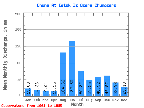
| Statistic | Jan | Feb | Mar | Apr | May | Jun | Jul | Aug | Sep | Oct | Nov | Dec | Annual |
|---|---|---|---|---|---|---|---|---|---|---|---|---|---|
| Mean | 19.02 | 14.48 | 14.04 | 13.55 | 104.64 | 132.30 | 60.21 | 39.54 | 46.92 | 49.86 | 32.98 | 23.09 | 546.16 |
| Standard Deviation | 4.15 | 3.61 | 2.65 | 3.35 | 49.81 | 34.04 | 24.16 | 12.61 | 12.74 | 17.60 | 10.53 | 4.82 | 80.95 |
| Min | 12.80 | 8.79 | 8.61 | 8.65 | 27.20 | 61.95 | 34.59 | 24.66 | 24.05 | 25.13 | 19.32 | 15.48 | 414.79 |
| Max | 26.78 | 24.36 | 18.07 | 21.91 | 209.44 | 177.20 | 119.08 | 65.89 | 69.24 | 86.13 | 67.88 | 32.15 | 675.99 |
| Coefficient of Variation | 0.22 | 0.25 | 0.19 | 0.25 | 0.48 | 0.26 | 0.40 | 0.32 | 0.27 | 0.35 | 0.32 | 0.21 | 0.15 |
 Return to R-Arctic Net Home Page