|
|
|||||||||||||||||
| Point ID: 9031 | Downloads | Plots | Site Data | Code: 71239 |
|
|
|||||||||||||||||
| Download | |
|---|---|
| Site Descriptor Information | Site Time Series Data |
| Link to all available data | |
| View: | Time Series | All |
| Units: | m3/s |
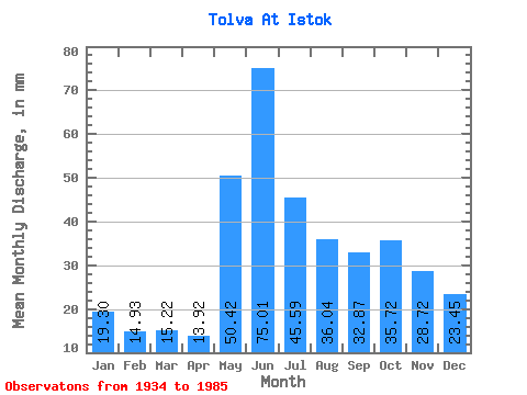
| Statistic | Jan | Feb | Mar | Apr | May | Jun | Jul | Aug | Sep | Oct | Nov | Dec | Annual |
|---|---|---|---|---|---|---|---|---|---|---|---|---|---|
| Mean | 19.29 | 15.05 | 15.22 | 13.92 | 50.41 | 75.01 | 45.59 | 36.04 | 32.87 | 35.71 | 28.72 | 23.45 | 392.79 |
| Standard Deviation | 4.04 | 3.30 | 2.38 | 2.34 | 22.03 | 21.23 | 14.03 | 12.35 | 7.59 | 9.07 | 6.19 | 3.62 | 60.85 |
| Min | 11.22 | 9.51 | 10.78 | 9.26 | 21.65 | 31.81 | 23.48 | 19.82 | 17.76 | 19.91 | 18.60 | 17.30 | 250.19 |
| Max | 27.65 | 23.37 | 21.48 | 19.95 | 87.82 | 118.66 | 93.90 | 65.91 | 50.75 | 52.95 | 47.04 | 31.21 | 510.46 |
| Coefficient of Variation | 0.21 | 0.22 | 0.16 | 0.17 | 0.44 | 0.28 | 0.31 | 0.34 | 0.23 | 0.25 | 0.21 | 0.15 | 0.15 |
 Return to R-Arctic Net Home Page