|
|
|||||||||||||||||
| Point ID: 9010 | Downloads | Plots | Site Data | Code: 71180 |
|
|
|||||||||||||||||
| Download | |
|---|---|
| Site Descriptor Information | Site Time Series Data |
| Link to all available data | |
| View: | Time Series | All |
| Units: | m3/s |
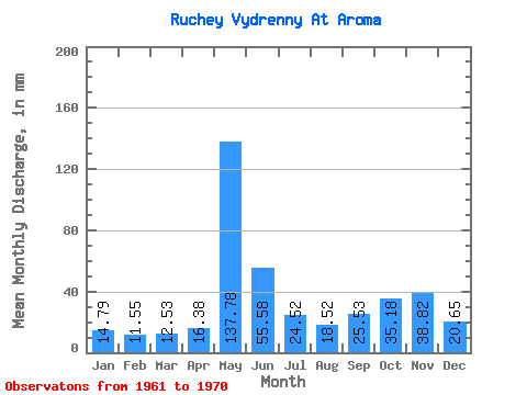
| Statistic | Jan | Feb | Mar | Apr | May | Jun | Jul | Aug | Sep | Oct | Nov | Dec | Annual |
|---|---|---|---|---|---|---|---|---|---|---|---|---|---|
| Mean | 14.77 | 11.67 | 12.52 | 16.36 | 137.74 | 55.61 | 24.48 | 18.45 | 25.53 | 35.23 | 38.83 | 20.65 | 415.56 |
| Standard Deviation | 2.74 | 2.24 | 2.28 | 8.08 | 53.21 | 20.84 | 4.33 | 3.45 | 8.27 | 10.24 | 18.54 | 6.68 | 81.33 |
| Min | 9.73 | 9.10 | 9.73 | 8.77 | 74.61 | 30.95 | 18.65 | 11.72 | 11.86 | 14.66 | 15.47 | 11.32 | 325.02 |
| Max | 19.98 | 14.57 | 15.99 | 29.66 | 241.23 | 95.43 | 31.98 | 22.65 | 37.40 | 47.96 | 70.92 | 30.64 | 590.06 |
| Coefficient of Variation | 0.19 | 0.19 | 0.18 | 0.49 | 0.39 | 0.38 | 0.18 | 0.19 | 0.32 | 0.29 | 0.48 | 0.32 | 0.20 |
 Return to R-Arctic Net Home Page