|
|
|||||||||||||||||
| Point ID: 9007 | Downloads | Plots | Site Data | Code: 71171 |
|
|
|||||||||||||||||
| Download | |
|---|---|
| Site Descriptor Information | Site Time Series Data |
| Link to all available data | |
| View: | Time Series | All |
| Units: | m3/s |
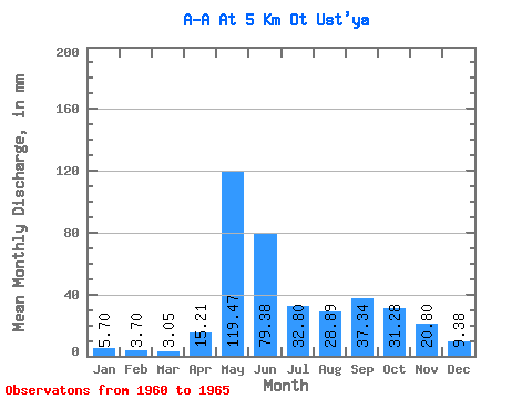
| Statistic | Jan | Feb | Mar | Apr | May | Jun | Jul | Aug | Sep | Oct | Nov | Dec | Annual |
|---|---|---|---|---|---|---|---|---|---|---|---|---|---|
| Mean | 5.70 | 3.74 | 3.05 | 15.21 | 119.45 | 79.39 | 32.80 | 28.89 | 37.34 | 31.27 | 20.80 | 9.38 | 433.01 |
| Standard Deviation | 1.84 | 1.67 | 1.20 | 17.35 | 66.10 | 48.71 | 11.76 | 15.66 | 18.57 | 19.63 | 11.74 | 5.73 | 66.37 |
| Min | 4.02 | 2.69 | 1.87 | 2.80 | 48.72 | 33.83 | 14.26 | 13.90 | 19.85 | 10.02 | 6.63 | 3.69 | 368.93 |
| Max | 8.37 | 6.67 | 5.04 | 47.95 | 200.64 | 173.16 | 45.41 | 48.44 | 61.00 | 62.48 | 37.30 | 18.69 | 502.30 |
| Coefficient of Variation | 0.32 | 0.45 | 0.39 | 1.14 | 0.55 | 0.61 | 0.36 | 0.54 | 0.50 | 0.63 | 0.56 | 0.61 | 0.15 |
 Return to R-Arctic Net Home Page