|
|
|||||||||||||||||
| Point ID: 9002 | Downloads | Plots | Site Data | Code: 71153 |
|
|
|||||||||||||||||
| Download | |
|---|---|
| Site Descriptor Information | Site Time Series Data |
| Link to all available data | |
| View: | Time Series | All |
| Units: | m3/s |
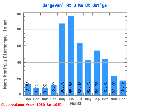
| Statistic | Jan | Feb | Mar | Apr | May | Jun | Jul | Aug | Sep | Oct | Nov | Dec | Annual |
|---|---|---|---|---|---|---|---|---|---|---|---|---|---|
| Mean | 13.92 | 9.49 | 9.22 | 12.29 | 86.94 | 95.91 | 63.48 | 42.78 | 54.22 | 43.72 | 23.65 | 18.16 | 480.25 |
| Standard Deviation | 2.16 | 1.83 | 1.66 | 5.47 | 31.20 | 25.28 | 33.23 | 13.88 | 24.07 | 17.74 | 5.20 | 3.25 | 68.38 |
| Min | 9.54 | 5.59 | 5.09 | 7.71 | 25.34 | 52.98 | 28.22 | 21.03 | 26.30 | 18.68 | 14.41 | 12.41 | 369.87 |
| Max | 17.64 | 12.86 | 11.37 | 28.45 | 145.00 | 130.23 | 129.98 | 62.31 | 98.62 | 81.25 | 30.85 | 24.95 | 563.72 |
| Coefficient of Variation | 0.15 | 0.19 | 0.18 | 0.45 | 0.36 | 0.26 | 0.52 | 0.32 | 0.44 | 0.41 | 0.22 | 0.18 | 0.14 |
 Return to R-Arctic Net Home Page