|
|
|||||||||||||||||
| Point ID: 8988 | Downloads | Plots | Site Data | Code: 71126 |
|
|
|||||||||||||||||
| Download | |
|---|---|
| Site Descriptor Information | Site Time Series Data |
| Link to all available data | |
| View: | Time Series | All |
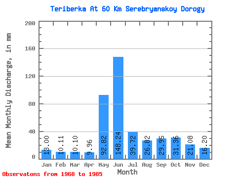
| Units: | m3/s |
| Statistic | Jan | Feb | Mar | Apr | May | Jun | Jul | Aug | Sep | Oct | Nov | Dec | Annual |
|---|---|---|---|---|---|---|---|---|---|---|---|---|---|
| Mean | 13.00 | 10.20 | 10.10 | 9.96 | 92.80 | 148.24 | 39.71 | 26.81 | 29.95 | 31.36 | 21.09 | 16.20 | 450.80 |
| Standard Deviation | 2.23 | 1.90 | 2.64 | 3.12 | 72.09 | 53.24 | 18.39 | 10.34 | 13.53 | 9.22 | 6.08 | 3.52 | 88.75 |
| Min | 9.59 | 6.46 | 5.22 | 5.53 | 8.73 | 74.18 | 15.30 | 11.83 | 15.36 | 18.69 | 14.61 | 11.17 | 289.33 |
| Max | 17.48 | 13.44 | 15.13 | 18.25 | 222.16 | 221.14 | 78.65 | 42.48 | 73.90 | 44.20 | 38.62 | 24.57 | 582.72 |
| Coefficient of Variation | 0.17 | 0.19 | 0.26 | 0.31 | 0.78 | 0.36 | 0.46 | 0.39 | 0.45 | 0.29 | 0.29 | 0.22 | 0.20 |
 Return to R-Arctic Net Home Page