|
|
|||||||||||||||||
| Point ID: 8984 | Downloads | Plots | Site Data | Code: 71111 |
|
|
|||||||||||||||||
| Download | |
|---|---|
| Site Descriptor Information | Site Time Series Data |
| Link to all available data | |
| View: | Time Series | All |
| Units: | m3/s |
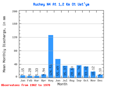
| Statistic | Jan | Feb | Mar | Apr | May | Jun | Jul | Aug | Sep | Oct | Nov | Dec | Annual |
|---|---|---|---|---|---|---|---|---|---|---|---|---|---|
| Mean | 7.11 | 5.38 | 5.32 | 9.94 | 126.55 | 55.46 | 35.40 | 28.66 | 36.73 | 33.06 | 18.06 | 9.04 | 370.17 |
| Standard Deviation | 2.52 | 2.27 | 2.50 | 9.10 | 47.48 | 20.15 | 17.40 | 14.58 | 22.82 | 13.31 | 9.80 | 3.21 | 94.20 |
| Min | 3.90 | 1.30 | 0.00 | 0.00 | 50.83 | 18.50 | 14.30 | 7.67 | 12.96 | 12.74 | 6.67 | 4.81 | 184.61 |
| Max | 13.00 | 9.00 | 9.49 | 31.46 | 210.60 | 91.47 | 83.20 | 49.40 | 111.10 | 62.53 | 44.16 | 18.20 | 544.51 |
| Coefficient of Variation | 0.35 | 0.42 | 0.47 | 0.92 | 0.38 | 0.36 | 0.49 | 0.51 | 0.62 | 0.40 | 0.54 | 0.36 | 0.25 |
 Return to R-Arctic Net Home Page