|
|
|||||||||||||||||
| Point ID: 8983 | Downloads | Plots | Site Data | Code: 71108 |
|
|
|||||||||||||||||
| Download | |
|---|---|
| Site Descriptor Information | Site Time Series Data |
| Link to all available data | |
| View: | Time Series | All |
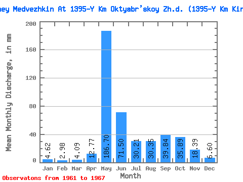
| Units: | m3/s |
| Statistic | Jan | Feb | Mar | Apr | May | Jun | Jul | Aug | Sep | Oct | Nov | Dec | Annual |
|---|---|---|---|---|---|---|---|---|---|---|---|---|---|
| Mean | 4.64 | 3.02 | 4.14 | 12.72 | 186.67 | 71.50 | 30.18 | 30.34 | 39.84 | 35.88 | 18.36 | 6.60 | 430.15 |
| Standard Deviation | 2.54 | 2.37 | 3.37 | 16.29 | 67.68 | 61.82 | 15.72 | 12.79 | 8.20 | 15.76 | 9.03 | 2.57 | 38.85 |
| Min | 0.00 | 0.00 | 0.13 | 0.13 | 83.11 | 31.92 | 12.40 | 17.15 | 31.92 | 14.51 | 11.88 | 3.43 | 372.09 |
| Max | 6.86 | 7.21 | 9.50 | 39.58 | 245.37 | 181.31 | 52.77 | 47.49 | 52.35 | 58.05 | 35.75 | 10.55 | 481.17 |
| Coefficient of Variation | 0.55 | 0.78 | 0.81 | 1.28 | 0.36 | 0.86 | 0.52 | 0.42 | 0.21 | 0.44 | 0.49 | 0.39 | 0.09 |
 Return to R-Arctic Net Home Page