|
|
|||||||||||||||||
| Point ID: 8968 | Downloads | Plots | Site Data | Code: 71078 |
|
|
|||||||||||||||||
| Download | |
|---|---|
| Site Descriptor Information | Site Time Series Data |
| Link to all available data | |
| View: | Time Series | All |
| Units: | m3/s |
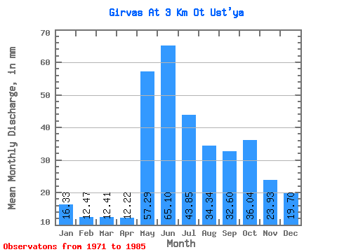
| Statistic | Jan | Feb | Mar | Apr | May | Jun | Jul | Aug | Sep | Oct | Nov | Dec | Annual |
|---|---|---|---|---|---|---|---|---|---|---|---|---|---|
| Mean | 16.33 | 12.58 | 12.41 | 12.22 | 57.28 | 65.10 | 43.84 | 34.33 | 32.60 | 36.03 | 23.93 | 19.70 | 338.07 |
| Standard Deviation | 2.11 | 1.44 | 0.98 | 1.24 | 8.83 | 18.15 | 17.04 | 11.94 | 8.38 | 4.13 | 3.21 | 2.70 | 16.83 |
| Min | 12.28 | 10.32 | 10.67 | 10.67 | 47.10 | 41.41 | 29.24 | 19.09 | 18.77 | 28.93 | 20.56 | 15.54 | 328.06 |
| Max | 19.39 | 15.57 | 13.87 | 14.49 | 66.95 | 108.60 | 93.42 | 60.18 | 48.56 | 42.17 | 29.50 | 22.62 | 357.50 |
| Coefficient of Variation | 0.13 | 0.12 | 0.08 | 0.10 | 0.15 | 0.28 | 0.39 | 0.35 | 0.26 | 0.12 | 0.13 | 0.14 | 0.05 |
 Return to R-Arctic Net Home Page