|
|
|||||||||||||||||
| Point ID: 8966 | Downloads | Plots | Site Data | Code: 71076 |
|
|
|||||||||||||||||
| Download | |
|---|---|
| Site Descriptor Information | Site Time Series Data |
| Link to all available data | |
| View: | Time Series | All |
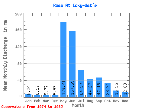
| Units: | m3/s |
| Statistic | Jan | Feb | Mar | Apr | May | Jun | Jul | Aug | Sep | Oct | Nov | Dec | Annual |
|---|---|---|---|---|---|---|---|---|---|---|---|---|---|
| Mean | 8.23 | 6.23 | 5.77 | 5.99 | 179.18 | 157.69 | 64.55 | 44.26 | 47.18 | 33.89 | 16.35 | 12.08 | 472.64 |
| Standard Deviation | 2.67 | 2.36 | 2.25 | 1.91 | 55.26 | 60.71 | 30.02 | 20.60 | 14.10 | 0.98 | 2.20 | 1.30 | 61.20 |
| Min | 6.09 | 4.09 | 3.53 | 3.48 | 72.16 | 99.33 | 29.51 | 19.56 | 26.39 | 33.03 | 13.97 | 10.90 | 429.37 |
| Max | 11.22 | 8.77 | 8.02 | 7.76 | 217.13 | 260.75 | 106.48 | 100.06 | 72.02 | 34.96 | 18.32 | 13.47 | 515.92 |
| Coefficient of Variation | 0.32 | 0.38 | 0.39 | 0.32 | 0.31 | 0.39 | 0.47 | 0.47 | 0.30 | 0.03 | 0.14 | 0.11 | 0.13 |
 Return to R-Arctic Net Home Page