|
|
|||||||||||||||||
| Point ID: 8957 | Downloads | Plots | Site Data | Code: 71036 |
|
|
|||||||||||||||||
| Download | |
|---|---|
| Site Descriptor Information | Site Time Series Data |
| Link to all available data | |
| View: | Time Series | All |
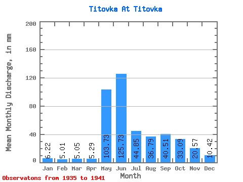
| Units: | m3/s |
| Statistic | Jan | Feb | Mar | Apr | May | Jun | Jul | Aug | Sep | Oct | Nov | Dec | Annual |
|---|---|---|---|---|---|---|---|---|---|---|---|---|---|
| Mean | 6.22 | 5.05 | 5.05 | 5.29 | 103.72 | 125.73 | 44.84 | 36.78 | 40.51 | 33.09 | 20.57 | 10.42 | 444.49 |
| Standard Deviation | 2.86 | 2.33 | 2.91 | 2.72 | 72.30 | 97.55 | 20.87 | 30.97 | 18.83 | 10.76 | 1.48 | 2.07 | 76.42 |
| Min | 3.19 | 2.91 | 2.32 | 1.56 | 35.49 | 36.00 | 10.18 | 4.61 | 8.95 | 21.89 | 18.93 | 9.22 | 390.45 |
| Max | 10.03 | 8.00 | 8.73 | 7.96 | 203.19 | 296.23 | 72.90 | 83.74 | 63.77 | 43.36 | 21.81 | 12.82 | 498.53 |
| Coefficient of Variation | 0.46 | 0.46 | 0.58 | 0.51 | 0.70 | 0.78 | 0.47 | 0.84 | 0.47 | 0.33 | 0.07 | 0.20 | 0.17 |
 Return to R-Arctic Net Home Page