|
|
|||||||||||||||||
| Point ID: 8956 | Downloads | Plots | Site Data | Code: 71034 |
|
|
|||||||||||||||||
| Download | |
|---|---|
| Site Descriptor Information | Site Time Series Data |
| Link to all available data | |
| View: | Time Series | All |
| Units: | m3/s |
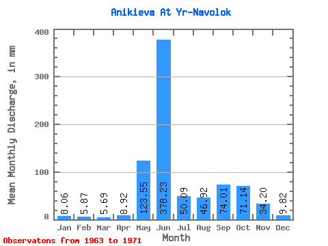
| Statistic | Jan | Feb | Mar | Apr | May | Jun | Jul | Aug | Sep | Oct | Nov | Dec | Annual |
|---|---|---|---|---|---|---|---|---|---|---|---|---|---|
| Mean | 8.05 | 5.91 | 5.68 | 8.93 | 123.55 | 378.20 | 50.09 | 46.93 | 74.00 | 71.14 | 34.23 | 9.82 | 838.42 |
| Standard Deviation | 2.48 | 1.74 | 1.65 | 10.82 | 106.47 | 128.11 | 26.42 | 35.66 | 39.13 | 17.24 | 21.71 | 3.62 | 143.68 |
| Min | 5.03 | 4.08 | 3.83 | 3.26 | 8.56 | 191.96 | 22.15 | 11.58 | 34.59 | 47.32 | 16.08 | 6.04 | 618.74 |
| Max | 11.07 | 9.17 | 7.55 | 35.57 | 271.32 | 540.81 | 98.66 | 111.75 | 163.71 | 105.21 | 74.06 | 15.61 | 1027.23 |
| Coefficient of Variation | 0.31 | 0.29 | 0.29 | 1.21 | 0.86 | 0.34 | 0.53 | 0.76 | 0.53 | 0.24 | 0.63 | 0.37 | 0.17 |
 Return to R-Arctic Net Home Page