|
|
|||||||||||||||||
| Point ID: 8952 | Downloads | Plots | Site Data | Code: 71029 |
|
|
|||||||||||||||||
| Download | |
|---|---|
| Site Descriptor Information | Site Time Series Data |
| Link to all available data | |
| View: | Time Series | All |
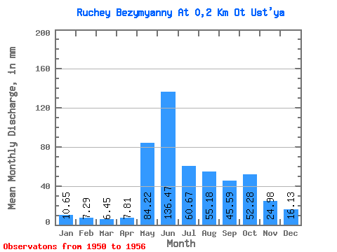
| Units: | m3/s |
| Statistic | Jan | Feb | Mar | Apr | May | Jun | Jul | Aug | Sep | Oct | Nov | Dec | Annual |
|---|---|---|---|---|---|---|---|---|---|---|---|---|---|
| Mean | 10.70 | 7.25 | 6.34 | 7.81 | 84.08 | 136.43 | 60.50 | 55.24 | 45.55 | 52.27 | 25.12 | 16.27 | 507.24 |
| Standard Deviation | 1.66 | 1.48 | 1.20 | 6.17 | 52.31 | 33.07 | 33.23 | 18.70 | 12.80 | 29.77 | 7.73 | 5.77 | 41.16 |
| Min | 9.03 | 5.88 | 5.16 | 4.68 | 17.10 | 87.44 | 29.36 | 27.75 | 29.36 | 26.46 | 12.18 | 11.29 | 434.74 |
| Max | 12.91 | 9.99 | 8.07 | 20.30 | 161.32 | 181.13 | 100.02 | 80.66 | 59.52 | 109.70 | 37.48 | 28.07 | 553.25 |
| Coefficient of Variation | 0.15 | 0.20 | 0.19 | 0.79 | 0.62 | 0.24 | 0.55 | 0.34 | 0.28 | 0.57 | 0.31 | 0.35 | 0.08 |
 Return to R-Arctic Net Home Page