|
|
|||||||||||||||||
| Point ID: 8951 | Downloads | Plots | Site Data | Code: 71028 |
|
|
|||||||||||||||||
| Download | |
|---|---|
| Site Descriptor Information | Site Time Series Data |
| Link to all available data | |
| View: | Time Series | All |
| Units: | m3/s |
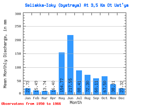
| Statistic | Jan | Feb | Mar | Apr | May | Jun | Jul | Aug | Sep | Oct | Nov | Dec | Annual |
|---|---|---|---|---|---|---|---|---|---|---|---|---|---|
| Mean | 22.73 | 15.61 | 13.72 | 16.42 | 154.75 | 217.55 | 88.39 | 72.29 | 60.11 | 67.51 | 38.30 | 23.31 | 771.48 |
| Standard Deviation | 10.64 | 7.28 | 5.43 | 7.97 | 89.72 | 58.34 | 43.81 | 28.07 | 19.50 | 24.18 | 15.57 | 9.75 | 117.02 |
| Min | 9.39 | 7.20 | 7.91 | 5.74 | 38.05 | 110.47 | 28.16 | 20.75 | 29.17 | 30.14 | 8.13 | 6.42 | 527.94 |
| Max | 37.06 | 24.76 | 22.73 | 32.04 | 339.94 | 300.33 | 174.42 | 112.16 | 90.86 | 114.14 | 58.82 | 37.55 | 940.39 |
| Coefficient of Variation | 0.47 | 0.47 | 0.40 | 0.48 | 0.58 | 0.27 | 0.50 | 0.39 | 0.32 | 0.36 | 0.41 | 0.42 | 0.15 |
 Return to R-Arctic Net Home Page