|
|
|||||||||||||||||
| Point ID: 8941 | Downloads | Plots | Site Data | Code: 71004 |
|
|
|||||||||||||||||
| Download | |
|---|---|
| Site Descriptor Information | Site Time Series Data |
| Link to all available data | |
| View: | Time Series | All |
| Units: | m3/s |
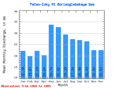
| Statistic | Jan | Feb | Mar | Apr | May | Jun | Jul | Aug | Sep | Oct | Nov | Dec | Annual |
|---|---|---|---|---|---|---|---|---|---|---|---|---|---|
| Mean | 22.18 | 20.04 | 22.23 | 20.24 | 33.74 | 32.62 | 29.38 | 27.33 | 26.98 | 26.42 | 22.50 | 22.53 | 305.96 |
| Standard Deviation | 4.05 | 4.16 | 5.21 | 4.51 | 7.71 | 9.04 | 14.29 | 11.16 | 11.80 | 7.15 | 3.67 | 3.54 | 54.05 |
| Min | 16.10 | 14.13 | 12.37 | 10.58 | 21.51 | 21.10 | 18.29 | 18.15 | 17.85 | 19.02 | 17.99 | 16.68 | 240.03 |
| Max | 28.39 | 27.87 | 36.59 | 31.30 | 49.02 | 55.81 | 69.80 | 54.29 | 68.69 | 40.68 | 30.31 | 28.10 | 391.77 |
| Coefficient of Variation | 0.18 | 0.21 | 0.23 | 0.22 | 0.23 | 0.28 | 0.49 | 0.41 | 0.44 | 0.27 | 0.16 | 0.16 | 0.18 |
 Return to R-Arctic Net Home Page