|
|
|||||||||||||||||
| Point ID: 894 | Downloads | Plots | Site Data | Code: 07FC004 |
|
|
|||||||||||||||||
| Download | |
|---|---|
| Site Descriptor Information | Site Time Series Data |
| Link to all available data | |
| View: | Time Series | All |
| Units: | m3/s |
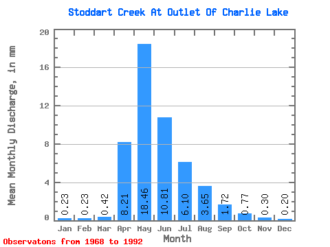
| Statistic | Jan | Feb | Mar | Apr | May | Jun | Jul | Aug | Sep | Oct | Nov | Dec | Annual |
|---|---|---|---|---|---|---|---|---|---|---|---|---|---|
| Mean | 0.24 | 0.23 | 0.42 | 8.21 | 18.46 | 10.81 | 6.10 | 3.65 | 1.72 | 0.77 | 0.31 | 0.20 | 50.31 |
| Standard Deviation | 0.33 | 0.36 | 0.54 | 9.51 | 20.26 | 13.15 | 6.75 | 5.98 | 3.28 | 1.42 | 0.65 | 0.31 | 40.33 |
| Min | 0.00 | 0.00 | 0.00 | 0.00 | 0.00 | 0.10 | 0.09 | 0.00 | 0.00 | 0.00 | 0.00 | 0.00 | 1.69 |
| Max | 0.94 | 1.02 | 1.56 | 32.44 | 64.07 | 51.58 | 20.58 | 21.39 | 11.92 | 4.33 | 2.37 | 0.92 | 124.95 |
| Coefficient of Variation | 1.42 | 1.55 | 1.27 | 1.16 | 1.10 | 1.22 | 1.11 | 1.64 | 1.91 | 1.83 | 2.10 | 1.58 | 0.80 |
 Return to R-Arctic Net Home Page