|
|
|||||||||||||||||
| Point ID: 8924 | Downloads | Plots | Site Data | Code: 70588 |
|
|
|||||||||||||||||
| Download | |
|---|---|
| Site Descriptor Information | Site Time Series Data |
| Link to all available data | |
| View: | Time Series | All |
| Units: | m3/s |
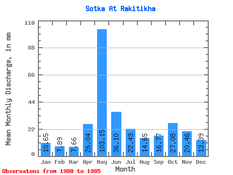
| Statistic | Jan | Feb | Mar | Apr | May | Jun | Jul | Aug | Sep | Oct | Nov | Dec | Annual |
|---|---|---|---|---|---|---|---|---|---|---|---|---|---|
| Mean | 10.65 | 7.96 | 7.66 | 26.04 | 103.14 | 36.10 | 22.43 | 14.65 | 16.77 | 27.08 | 20.46 | 13.38 | 319.80 |
| Standard Deviation | 2.86 | 1.55 | 1.63 | 38.53 | 33.87 | 18.80 | 14.18 | 6.84 | 9.93 | 14.87 | 8.22 | 4.69 | 63.18 |
| Min | 6.71 | 5.71 | 5.14 | 5.00 | 56.85 | 19.82 | 11.06 | 8.56 | 8.65 | 8.08 | 6.89 | 7.36 | 223.15 |
| Max | 13.56 | 9.42 | 9.42 | 94.80 | 138.01 | 72.92 | 48.29 | 27.16 | 35.13 | 46.23 | 28.27 | 20.65 | 380.64 |
| Coefficient of Variation | 0.27 | 0.20 | 0.21 | 1.48 | 0.33 | 0.52 | 0.63 | 0.47 | 0.59 | 0.55 | 0.40 | 0.35 | 0.20 |
 Return to R-Arctic Net Home Page