|
|
|||||||||||||||||
| Point ID: 8920 | Downloads | Plots | Site Data | Code: 70584 |
|
|
|||||||||||||||||
| Download | |
|---|---|
| Site Descriptor Information | Site Time Series Data |
| Link to all available data | |
| View: | Time Series | All |
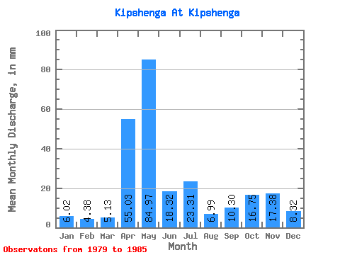
| Units: | m3/s |
| Statistic | Jan | Feb | Mar | Apr | May | Jun | Jul | Aug | Sep | Oct | Nov | Dec | Annual |
|---|---|---|---|---|---|---|---|---|---|---|---|---|---|
| Mean | 6.02 | 4.42 | 5.13 | 55.03 | 84.96 | 18.32 | 23.31 | 6.99 | 10.30 | 16.75 | 17.38 | 8.32 | 262.54 |
| Standard Deviation | 1.21 | 1.30 | 3.55 | 31.03 | 60.72 | 14.83 | 21.70 | 6.35 | 7.85 | 12.88 | 12.18 | 1.75 | 42.24 |
| Min | 4.20 | 2.51 | 3.00 | 10.26 | 10.21 | 4.07 | 2.69 | 2.69 | 3.32 | 7.46 | 7.80 | 6.57 | 186.04 |
| Max | 7.63 | 6.15 | 12.01 | 90.28 | 183.36 | 44.80 | 62.53 | 21.16 | 24.66 | 44.52 | 43.43 | 11.66 | 303.60 |
| Coefficient of Variation | 0.20 | 0.29 | 0.69 | 0.56 | 0.71 | 0.81 | 0.93 | 0.91 | 0.76 | 0.77 | 0.70 | 0.21 | 0.16 |
 Return to R-Arctic Net Home Page