|
|
|||||||||||||||||
| Point ID: 8919 | Downloads | Plots | Site Data | Code: 70583 |
|
|
|||||||||||||||||
| Download | |
|---|---|
| Site Descriptor Information | Site Time Series Data |
| Link to all available data | |
| View: | Time Series | All |
| Units: | m3/s |
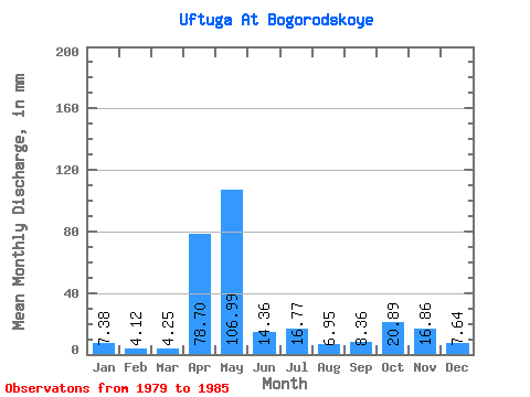
| Statistic | Jan | Feb | Mar | Apr | May | Jun | Jul | Aug | Sep | Oct | Nov | Dec | Annual |
|---|---|---|---|---|---|---|---|---|---|---|---|---|---|
| Mean | 7.38 | 4.15 | 4.25 | 78.70 | 106.98 | 14.36 | 16.77 | 6.95 | 8.36 | 20.89 | 16.86 | 7.64 | 295.69 |
| Standard Deviation | 6.36 | 2.33 | 1.22 | 70.53 | 59.72 | 7.54 | 13.35 | 3.41 | 7.58 | 16.68 | 10.00 | 3.23 | 53.52 |
| Min | 1.43 | 1.11 | 2.44 | 11.88 | 27.72 | 6.92 | 5.30 | 3.10 | 3.68 | 4.92 | 8.64 | 3.45 | 241.36 |
| Max | 19.00 | 7.47 | 5.61 | 198.45 | 209.57 | 29.13 | 39.75 | 12.20 | 23.62 | 45.33 | 36.45 | 12.59 | 365.22 |
| Coefficient of Variation | 0.86 | 0.56 | 0.29 | 0.90 | 0.56 | 0.53 | 0.80 | 0.49 | 0.91 | 0.80 | 0.59 | 0.42 | 0.18 |
 Return to R-Arctic Net Home Page