|
|
|||||||||||||||||
| Point ID: 8915 | Downloads | Plots | Site Data | Code: 70579 |
|
|
|||||||||||||||||
| Download | |
|---|---|
| Site Descriptor Information | Site Time Series Data |
| Link to all available data | |
| View: | Time Series | All |
| Units: | m3/s |
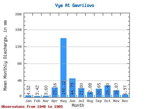
| Statistic | Jan | Feb | Mar | Apr | May | Jun | Jul | Aug | Sep | Oct | Nov | Dec | Annual |
|---|---|---|---|---|---|---|---|---|---|---|---|---|---|
| Mean | 4.52 | 3.45 | 3.60 | 23.16 | 140.10 | 44.79 | 21.80 | 12.88 | 20.64 | 28.40 | 16.87 | 6.97 | 323.14 |
| Standard Deviation | 1.44 | 0.77 | 0.66 | 33.66 | 52.49 | 22.44 | 13.50 | 10.62 | 14.91 | 15.55 | 11.15 | 3.76 | 63.60 |
| Min | 1.59 | 1.48 | 2.16 | 2.83 | 36.55 | 12.11 | 5.09 | 2.72 | 4.40 | 6.36 | 4.80 | 1.42 | 188.46 |
| Max | 7.49 | 4.82 | 5.12 | 134.91 | 238.17 | 101.02 | 49.06 | 54.77 | 61.40 | 74.41 | 44.09 | 19.76 | 449.98 |
| Coefficient of Variation | 0.32 | 0.22 | 0.18 | 1.45 | 0.38 | 0.50 | 0.62 | 0.82 | 0.72 | 0.55 | 0.66 | 0.54 | 0.20 |
 Return to R-Arctic Net Home Page