|
|
|||||||||||||||||
| Point ID: 8913 | Downloads | Plots | Site Data | Code: 70577 |
|
|
|||||||||||||||||
| Download | |
|---|---|
| Site Descriptor Information | Site Time Series Data |
| Link to all available data | |
| View: | Time Series | All |
| Units: | m3/s |
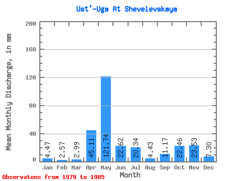
| Statistic | Jan | Feb | Mar | Apr | May | Jun | Jul | Aug | Sep | Oct | Nov | Dec | Annual |
|---|---|---|---|---|---|---|---|---|---|---|---|---|---|
| Mean | 4.47 | 2.60 | 2.98 | 45.11 | 121.72 | 22.62 | 20.34 | 4.43 | 11.17 | 22.46 | 23.53 | 7.30 | 287.15 |
| Standard Deviation | 2.94 | 1.41 | 1.95 | 39.59 | 66.84 | 18.63 | 17.20 | 2.13 | 8.90 | 15.15 | 18.93 | 4.75 | 53.13 |
| Min | 1.96 | 1.25 | 1.67 | 5.65 | 22.17 | 3.89 | 2.45 | 1.81 | 1.95 | 6.18 | 10.44 | 2.60 | 205.97 |
| Max | 7.85 | 5.05 | 7.11 | 102.07 | 243.28 | 48.90 | 41.10 | 8.00 | 25.87 | 53.95 | 65.04 | 16.43 | 364.68 |
| Coefficient of Variation | 0.66 | 0.54 | 0.66 | 0.88 | 0.55 | 0.82 | 0.85 | 0.48 | 0.80 | 0.68 | 0.81 | 0.65 | 0.18 |
 Return to R-Arctic Net Home Page