|
|
|||||||||||||||||
| Point ID: 8904 | Downloads | Plots | Site Data | Code: 70564 |
|
|
|||||||||||||||||
| Download | |
|---|---|
| Site Descriptor Information | Site Time Series Data |
| Link to all available data | |
| View: | Time Series | All |
| Units: | m3/s |
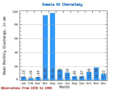
| Statistic | Jan | Feb | Mar | Apr | May | Jun | Jul | Aug | Sep | Oct | Nov | Dec | Annual |
|---|---|---|---|---|---|---|---|---|---|---|---|---|---|
| Mean | 5.13 | 3.07 | 4.64 | 93.53 | 96.61 | 15.33 | 11.02 | 5.85 | 5.87 | 11.97 | 18.38 | 9.22 | 284.23 |
| Standard Deviation | 4.30 | 2.27 | 5.83 | 48.75 | 49.67 | 13.98 | 12.13 | 8.46 | 7.55 | 15.62 | 14.94 | 7.49 | 53.29 |
| Min | 0.87 | 0.60 | 0.87 | 42.21 | 25.27 | 2.69 | 1.07 | 0.71 | 0.52 | 1.86 | 0.89 | 0.74 | 223.38 |
| Max | 13.70 | 7.25 | 19.49 | 193.54 | 180.32 | 45.17 | 37.24 | 27.29 | 25.18 | 52.28 | 40.24 | 23.85 | 400.61 |
| Coefficient of Variation | 0.84 | 0.74 | 1.26 | 0.52 | 0.51 | 0.91 | 1.10 | 1.45 | 1.29 | 1.30 | 0.81 | 0.81 | 0.19 |
 Return to R-Arctic Net Home Page