|
|
|||||||||||||||||
| Point ID: 8903 | Downloads | Plots | Site Data | Code: 70562 |
|
|
|||||||||||||||||
| Download | |
|---|---|
| Site Descriptor Information | Site Time Series Data |
| Link to all available data | |
| View: | Time Series | All |
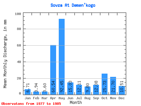
| Units: | m3/s |
| Statistic | Jan | Feb | Mar | Apr | May | Jun | Jul | Aug | Sep | Oct | Nov | Dec | Annual |
|---|---|---|---|---|---|---|---|---|---|---|---|---|---|
| Mean | 6.71 | 3.97 | 3.60 | 60.54 | 92.44 | 15.03 | 12.11 | 9.80 | 12.08 | 25.72 | 21.70 | 10.51 | 270.14 |
| Standard Deviation | 3.57 | 1.91 | 1.23 | 38.99 | 54.15 | 7.79 | 9.80 | 11.26 | 12.29 | 18.45 | 11.04 | 5.07 | 63.34 |
| Min | 1.50 | 1.58 | 1.78 | 10.62 | 27.69 | 7.41 | 3.69 | 1.73 | 2.51 | 4.55 | 7.54 | 2.60 | 162.18 |
| Max | 10.84 | 6.72 | 5.42 | 115.05 | 194.93 | 28.21 | 24.14 | 37.03 | 38.05 | 61.94 | 37.78 | 16.81 | 349.19 |
| Coefficient of Variation | 0.53 | 0.48 | 0.34 | 0.64 | 0.59 | 0.52 | 0.81 | 1.15 | 1.02 | 0.72 | 0.51 | 0.48 | 0.23 |
 Return to R-Arctic Net Home Page