|
|
|||||||||||||||||
| Point ID: 8886 | Downloads | Plots | Site Data | Code: 70529 |
|
|
|||||||||||||||||
| Download | |
|---|---|
| Site Descriptor Information | Site Time Series Data |
| Link to all available data | |
| View: | Time Series | All |
| Units: | m3/s |
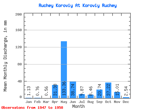
| Statistic | Jan | Feb | Mar | Apr | May | Jun | Jul | Aug | Sep | Oct | Nov | Dec | Annual |
|---|---|---|---|---|---|---|---|---|---|---|---|---|---|
| Mean | 1.17 | 0.66 | 0.59 | 31.24 | 133.34 | 38.62 | 9.79 | 8.48 | 20.66 | 37.11 | 14.98 | 2.66 | 316.46 |
| Standard Deviation | 1.08 | 0.68 | 0.28 | 41.10 | 58.91 | 18.97 | 10.79 | 9.67 | 15.74 | 27.50 | 16.49 | 2.54 | 82.11 |
| Min | 0.28 | 0.26 | 0.28 | 0.27 | 45.10 | 7.64 | 0.85 | 0.56 | 2.73 | 8.46 | 2.73 | 0.28 | 231.99 |
| Max | 3.10 | 2.06 | 1.13 | 109.14 | 222.70 | 65.48 | 36.65 | 33.83 | 43.66 | 107.12 | 46.38 | 7.05 | 443.22 |
| Coefficient of Variation | 0.93 | 1.02 | 0.48 | 1.32 | 0.44 | 0.49 | 1.10 | 1.14 | 0.76 | 0.74 | 1.10 | 0.95 | 0.26 |
 Return to R-Arctic Net Home Page