|
|
|||||||||||||||||
| Point ID: 8871 | Downloads | Plots | Site Data | Code: 70448 |
|
|
|||||||||||||||||
| Download | |
|---|---|
| Site Descriptor Information | Site Time Series Data |
| Link to all available data | |
| View: | Time Series | All |
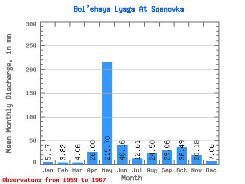
| Units: | m3/s |
| Statistic | Jan | Feb | Mar | Apr | May | Jun | Jul | Aug | Sep | Oct | Nov | Dec | Annual |
|---|---|---|---|---|---|---|---|---|---|---|---|---|---|
| Mean | 5.17 | 3.85 | 4.06 | 26.00 | 215.66 | 40.16 | 12.61 | 24.49 | 29.06 | 36.48 | 20.18 | 7.06 | 429.53 |
| Standard Deviation | 0.63 | 0.40 | 0.42 | 34.77 | 42.98 | 13.56 | 5.53 | 27.38 | 22.04 | 25.95 | 14.05 | 1.27 | 83.06 |
| Min | 4.06 | 3.31 | 3.74 | 4.08 | 127.54 | 18.43 | 7.00 | 4.00 | 5.26 | 10.31 | 8.21 | 5.70 | 269.46 |
| Max | 5.81 | 4.42 | 5.01 | 104.71 | 254.81 | 59.03 | 21.80 | 64.17 | 61.08 | 83.52 | 49.27 | 9.76 | 519.36 |
| Coefficient of Variation | 0.12 | 0.10 | 0.10 | 1.34 | 0.20 | 0.34 | 0.44 | 1.12 | 0.76 | 0.71 | 0.70 | 0.18 | 0.19 |
 Return to R-Arctic Net Home Page