|
|
|||||||||||||||||
| Point ID: 8870 | Downloads | Plots | Site Data | Code: 70446 |
|
|
|||||||||||||||||
| Download | |
|---|---|
| Site Descriptor Information | Site Time Series Data |
| Link to all available data | |
| View: | Time Series | All |
| Units: | m3/s |
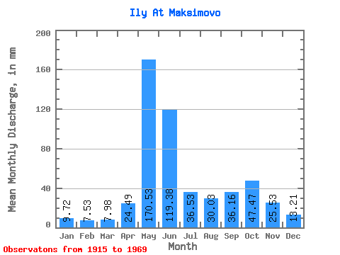
| Statistic | Jan | Feb | Mar | Apr | May | Jun | Jul | Aug | Sep | Oct | Nov | Dec | Annual |
|---|---|---|---|---|---|---|---|---|---|---|---|---|---|
| Mean | 9.72 | 7.59 | 7.97 | 24.49 | 170.51 | 119.38 | 36.52 | 30.02 | 36.16 | 47.47 | 25.53 | 13.21 | 528.61 |
| Standard Deviation | 2.36 | 1.56 | 1.45 | 26.83 | 53.73 | 55.06 | 18.76 | 19.64 | 19.09 | 21.58 | 10.93 | 3.15 | 85.39 |
| Min | 4.36 | 3.98 | 4.36 | 6.24 | 47.11 | 36.72 | 14.78 | 8.88 | 8.83 | 12.50 | 9.82 | 7.29 | 311.41 |
| Max | 14.41 | 11.41 | 12.52 | 127.92 | 290.12 | 288.00 | 119.77 | 83.56 | 90.96 | 108.36 | 58.56 | 23.93 | 712.63 |
| Coefficient of Variation | 0.24 | 0.21 | 0.18 | 1.09 | 0.32 | 0.46 | 0.51 | 0.65 | 0.53 | 0.46 | 0.43 | 0.24 | 0.16 |
 Return to R-Arctic Net Home Page