|
|
|||||||||||||||||
| Point ID: 8868 | Downloads | Plots | Site Data | Code: 70416 |
|
|
|||||||||||||||||
| Download | |
|---|---|
| Site Descriptor Information | Site Time Series Data |
| Link to all available data | |
| View: | Time Series | All |
| Units: | m3/s |
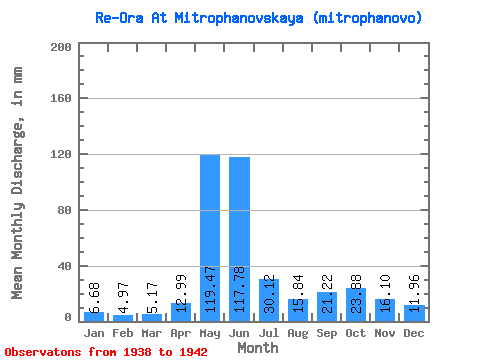
| Statistic | Jan | Feb | Mar | Apr | May | Jun | Jul | Aug | Sep | Oct | Nov | Dec | Annual |
|---|---|---|---|---|---|---|---|---|---|---|---|---|---|
| Mean | 6.68 | 5.01 | 5.17 | 12.99 | 119.45 | 117.78 | 30.12 | 15.84 | 21.22 | 23.88 | 16.10 | 11.96 | 385.23 |
| Standard Deviation | 0.82 | 0.59 | 0.92 | 10.49 | 9.49 | 59.37 | 9.03 | 5.06 | 12.88 | 10.04 | 5.13 | 2.92 | 90.45 |
| Min | 5.95 | 4.59 | 3.85 | 4.61 | 106.61 | 25.11 | 20.04 | 11.69 | 10.82 | 10.21 | 12.12 | 9.05 | 235.69 |
| Max | 8.03 | 6.03 | 6.29 | 29.77 | 131.01 | 175.29 | 44.83 | 24.60 | 43.51 | 35.77 | 24.86 | 16.05 | 464.19 |
| Coefficient of Variation | 0.12 | 0.12 | 0.18 | 0.81 | 0.08 | 0.50 | 0.30 | 0.32 | 0.61 | 0.42 | 0.32 | 0.24 | 0.23 |
 Return to R-Arctic Net Home Page