|
|
|||||||||||||||||
| Point ID: 8847 | Downloads | Plots | Site Data | Code: 70171 |
|
|
|||||||||||||||||
| Download | |
|---|---|
| Site Descriptor Information | Site Time Series Data |
| Link to all available data | |
| View: | Time Series | All |
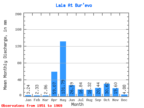
| Units: | m3/s |
| Statistic | Jan | Feb | Mar | Apr | May | Jun | Jul | Aug | Sep | Oct | Nov | Dec | Annual |
|---|---|---|---|---|---|---|---|---|---|---|---|---|---|
| Mean | 3.24 | 2.35 | 2.87 | 59.07 | 131.77 | 26.59 | 16.84 | 16.32 | 20.45 | 30.62 | 19.60 | 4.88 | 336.45 |
| Standard Deviation | 1.35 | 1.18 | 1.61 | 48.95 | 65.33 | 13.61 | 10.88 | 16.46 | 26.28 | 24.04 | 13.25 | 1.79 | 113.63 |
| Min | 0.91 | 0.57 | 1.01 | 3.45 | 20.72 | 9.18 | 4.85 | 3.75 | 3.90 | 5.10 | 5.36 | 2.11 | 121.75 |
| Max | 6.39 | 5.59 | 8.44 | 160.51 | 234.91 | 57.04 | 39.74 | 61.40 | 117.79 | 108.82 | 54.39 | 7.98 | 621.62 |
| Coefficient of Variation | 0.42 | 0.50 | 0.56 | 0.83 | 0.50 | 0.51 | 0.65 | 1.01 | 1.28 | 0.79 | 0.68 | 0.37 | 0.34 |
 Return to R-Arctic Net Home Page