|
|
|||||||||||||||||
| Point ID: 8846 | Downloads | Plots | Site Data | Code: 70157 |
|
|
|||||||||||||||||
| Download | |
|---|---|
| Site Descriptor Information | Site Time Series Data |
| Link to all available data | |
| View: | Time Series | All |
| Units: | m3/s |
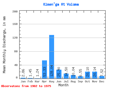
| Statistic | Jan | Feb | Mar | Apr | May | Jun | Jul | Aug | Sep | Oct | Nov | Dec | Annual |
|---|---|---|---|---|---|---|---|---|---|---|---|---|---|
| Mean | 2.85 | 1.46 | 1.24 | 53.33 | 128.03 | 25.90 | 14.50 | 10.04 | 6.55 | 20.10 | 20.14 | 7.52 | 293.75 |
| Standard Deviation | 1.52 | 0.57 | 0.34 | 45.72 | 69.39 | 16.15 | 20.83 | 15.05 | 6.09 | 12.87 | 10.91 | 4.68 | 85.48 |
| Min | 0.69 | 0.75 | 0.63 | 6.07 | 32.93 | 2.57 | 1.33 | 1.45 | 1.98 | 3.38 | 4.67 | 2.05 | 184.51 |
| Max | 6.15 | 2.53 | 1.69 | 145.95 | 238.85 | 67.48 | 73.83 | 49.10 | 24.64 | 46.21 | 36.09 | 19.54 | 458.72 |
| Coefficient of Variation | 0.53 | 0.39 | 0.28 | 0.86 | 0.54 | 0.62 | 1.44 | 1.50 | 0.93 | 0.64 | 0.54 | 0.62 | 0.29 |
 Return to R-Arctic Net Home Page