|
|
|||||||||||||||||
| Point ID: 8833 | Downloads | Plots | Site Data | Code: 70039 |
|
|
|||||||||||||||||
| Download | |
|---|---|
| Site Descriptor Information | Site Time Series Data |
| Link to all available data | |
| View: | Time Series | All |
| Units: | m3/s |
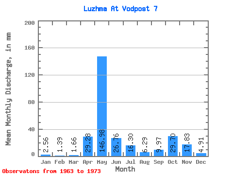
| Statistic | Jan | Feb | Mar | Apr | May | Jun | Jul | Aug | Sep | Oct | Nov | Dec | Annual |
|---|---|---|---|---|---|---|---|---|---|---|---|---|---|
| Mean | 2.56 | 1.41 | 1.66 | 29.28 | 146.96 | 26.76 | 16.30 | 6.29 | 9.97 | 29.70 | 17.83 | 4.92 | 316.75 |
| Standard Deviation | 0.81 | 0.24 | 0.62 | 22.35 | 82.02 | 12.29 | 16.27 | 7.03 | 4.45 | 19.71 | 7.68 | 1.77 | 87.63 |
| Min | 1.58 | 1.05 | 0.97 | 9.93 | 61.33 | 7.64 | 1.82 | 1.20 | 5.24 | 17.79 | 9.05 | 2.89 | 213.04 |
| Max | 3.30 | 1.68 | 2.61 | 66.42 | 250.80 | 41.44 | 43.42 | 20.40 | 16.40 | 69.23 | 31.62 | 8.14 | 442.81 |
| Coefficient of Variation | 0.31 | 0.17 | 0.38 | 0.76 | 0.56 | 0.46 | 1.00 | 1.12 | 0.45 | 0.66 | 0.43 | 0.36 | 0.28 |
 Return to R-Arctic Net Home Page