|
|
|||||||||||||||||
| Point ID: 8832 | Downloads | Plots | Site Data | Code: 70038 |
|
|
|||||||||||||||||
| Download | |
|---|---|
| Site Descriptor Information | Site Time Series Data |
| Link to all available data | |
| View: | Time Series | All |
| Units: | m3/s |
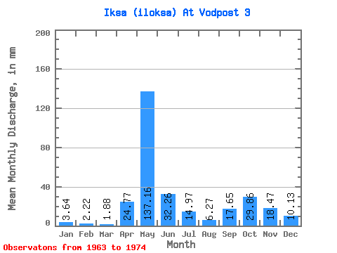
| Statistic | Jan | Feb | Mar | Apr | May | Jun | Jul | Aug | Sep | Oct | Nov | Dec | Annual |
|---|---|---|---|---|---|---|---|---|---|---|---|---|---|
| Mean | 3.64 | 2.24 | 1.88 | 24.77 | 137.14 | 32.26 | 14.97 | 6.27 | 17.65 | 29.86 | 18.47 | 10.13 | 297.68 |
| Standard Deviation | 1.58 | 1.56 | 0.80 | 27.80 | 45.03 | 15.12 | 12.17 | 5.10 | 19.81 | 21.91 | 9.48 | 8.79 | 76.72 |
| Min | 1.55 | 0.95 | 1.06 | 3.99 | 71.36 | 9.78 | 1.49 | 1.19 | 1.33 | 2.58 | 6.53 | 4.57 | 199.71 |
| Max | 6.58 | 6.63 | 3.25 | 91.11 | 208.47 | 63.95 | 39.77 | 14.61 | 69.07 | 69.60 | 39.27 | 32.39 | 430.80 |
| Coefficient of Variation | 0.43 | 0.69 | 0.43 | 1.12 | 0.33 | 0.47 | 0.81 | 0.81 | 1.12 | 0.73 | 0.51 | 0.87 | 0.26 |
 Return to R-Arctic Net Home Page