|
|
|||||||||||||||||
| Point ID: 8829 | Downloads | Plots | Site Data | Code: 70034 |
|
|
|||||||||||||||||
| Download | |
|---|---|
| Site Descriptor Information | Site Time Series Data |
| Link to all available data | |
| View: | Time Series | All |
| Units: | m3/s |
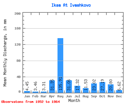
| Statistic | Jan | Feb | Mar | Apr | May | Jun | Jul | Aug | Sep | Oct | Nov | Dec | Annual |
|---|---|---|---|---|---|---|---|---|---|---|---|---|---|
| Mean | 4.45 | 3.49 | 3.31 | 31.35 | 135.89 | 31.06 | 17.32 | 11.53 | 23.02 | 27.19 | 20.80 | 6.62 | 309.95 |
| Standard Deviation | 1.44 | 1.34 | 0.81 | 39.59 | 56.72 | 16.82 | 6.30 | 11.43 | 20.20 | 14.87 | 17.28 | 2.78 | 91.18 |
| Min | 2.26 | 1.81 | 2.03 | 3.75 | 33.51 | 14.59 | 8.39 | 3.41 | 3.84 | 10.74 | 4.55 | 2.67 | 166.04 |
| Max | 6.54 | 6.38 | 4.79 | 124.02 | 213.87 | 66.92 | 27.38 | 44.85 | 60.23 | 52.55 | 66.92 | 12.22 | 442.30 |
| Coefficient of Variation | 0.32 | 0.38 | 0.24 | 1.26 | 0.42 | 0.54 | 0.36 | 0.99 | 0.88 | 0.55 | 0.83 | 0.42 | 0.29 |
 Return to R-Arctic Net Home Page