|
|
|||||||||||||||||
| Point ID: 8824 | Downloads | Plots | Site Data | Code: 12424 |
|
|
|||||||||||||||||
| Download | |
|---|---|
| Site Descriptor Information | Site Time Series Data |
| Link to all available data | |
| View: | Time Series | All |
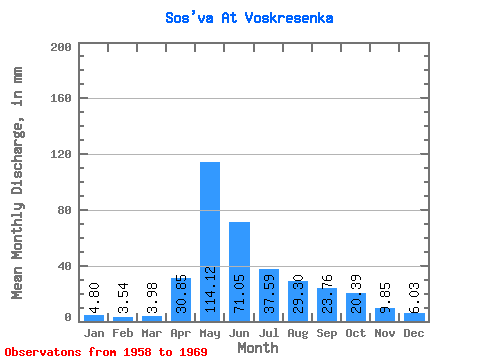
| Units: | m3/s |
| Statistic | Jan | Feb | Mar | Apr | May | Jun | Jul | Aug | Sep | Oct | Nov | Dec | Annual |
|---|---|---|---|---|---|---|---|---|---|---|---|---|---|
| Mean | 4.80 | 3.57 | 3.98 | 30.85 | 114.10 | 71.05 | 37.58 | 29.30 | 23.76 | 20.38 | 9.85 | 6.03 | 362.43 |
| Standard Deviation | 1.33 | 1.25 | 1.15 | 19.20 | 48.58 | 44.04 | 34.01 | 27.27 | 7.64 | 7.72 | 5.80 | 1.69 | 81.77 |
| Min | 2.37 | 1.07 | 1.10 | 4.87 | 46.51 | 32.74 | 12.19 | 7.47 | 12.12 | 13.44 | 3.93 | 3.34 | 279.73 |
| Max | 7.35 | 5.18 | 5.45 | 69.80 | 186.28 | 168.25 | 128.73 | 85.51 | 38.65 | 35.00 | 25.46 | 10.01 | 538.55 |
| Coefficient of Variation | 0.28 | 0.35 | 0.29 | 0.62 | 0.43 | 0.62 | 0.91 | 0.93 | 0.32 | 0.38 | 0.59 | 0.28 | 0.23 |
 Return to R-Arctic Net Home Page