|
|
|||||||||||||||||
| Point ID: 8807 | Downloads | Plots | Site Data | Code: 12298 |
|
|
|||||||||||||||||
| Download | |
|---|---|
| Site Descriptor Information | Site Time Series Data |
| Link to all available data | |
| View: | Time Series | All |
| Units: | m3/s |
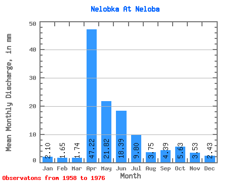
| Statistic | Jan | Feb | Mar | Apr | May | Jun | Jul | Aug | Sep | Oct | Nov | Dec | Annual |
|---|---|---|---|---|---|---|---|---|---|---|---|---|---|
| Mean | 2.10 | 1.66 | 1.74 | 47.21 | 21.82 | 18.38 | 9.80 | 3.74 | 4.39 | 5.63 | 3.54 | 2.43 | 122.69 |
| Standard Deviation | 0.97 | 0.99 | 0.82 | 34.60 | 17.45 | 22.65 | 16.73 | 2.14 | 3.41 | 4.08 | 2.09 | 1.54 | 70.04 |
| Min | 1.05 | 0.94 | 0.43 | 10.79 | 4.70 | 3.17 | 1.64 | 1.64 | 1.48 | 1.86 | 1.38 | 1.09 | 48.95 |
| Max | 4.48 | 4.18 | 3.50 | 98.92 | 58.04 | 67.50 | 50.94 | 7.54 | 11.32 | 13.01 | 7.19 | 5.68 | 232.30 |
| Coefficient of Variation | 0.46 | 0.59 | 0.47 | 0.73 | 0.80 | 1.23 | 1.71 | 0.57 | 0.78 | 0.73 | 0.59 | 0.63 | 0.57 |
 Return to R-Arctic Net Home Page