|
|
|||||||||||||||||
| Point ID: 8798 | Downloads | Plots | Site Data | Code: 12262 |
|
|
|||||||||||||||||
| Download | |
|---|---|
| Site Descriptor Information | Site Time Series Data |
| Link to all available data | |
| View: | Time Series | All |
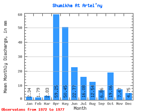
| Units: | m3/s |
| Statistic | Jan | Feb | Mar | Apr | May | Jun | Jul | Aug | Sep | Oct | Nov | Dec | Annual |
|---|---|---|---|---|---|---|---|---|---|---|---|---|---|
| Mean | 2.34 | 1.82 | 2.84 | 59.25 | 50.47 | 22.77 | 16.08 | 12.54 | 6.89 | 19.05 | 7.47 | 4.72 | 224.79 |
| Standard Deviation | 1.97 | 1.61 | 2.01 | 42.08 | 29.91 | 21.70 | 16.69 | 5.13 | 2.02 | 17.51 | 4.82 | 2.57 | 78.25 |
| Min | 0.00 | 0.00 | 0.00 | 36.34 | 22.67 | 4.09 | 3.61 | 3.83 | 3.98 | 3.83 | 1.71 | 1.13 | 154.67 |
| Max | 4.79 | 3.52 | 4.82 | 134.40 | 100.64 | 60.38 | 42.51 | 16.30 | 8.91 | 47.51 | 15.09 | 7.79 | 296.36 |
| Coefficient of Variation | 0.84 | 0.89 | 0.71 | 0.71 | 0.59 | 0.95 | 1.04 | 0.41 | 0.29 | 0.92 | 0.65 | 0.54 | 0.35 |
 Return to R-Arctic Net Home Page