|
|
|||||||||||||||||
| Point ID: 8790 | Downloads | Plots | Site Data | Code: 12221 |
|
|
|||||||||||||||||
| Download | |
|---|---|
| Site Descriptor Information | Site Time Series Data |
| Link to all available data | |
| View: | Time Series | All |
| Units: | m3/s |
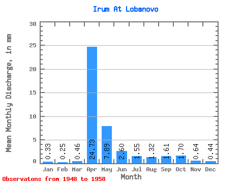
| Statistic | Jan | Feb | Mar | Apr | May | Jun | Jul | Aug | Sep | Oct | Nov | Dec | Annual |
|---|---|---|---|---|---|---|---|---|---|---|---|---|---|
| Mean | 0.33 | 0.26 | 0.46 | 24.73 | 7.89 | 2.60 | 1.55 | 1.32 | 1.61 | 1.70 | 0.64 | 0.44 | 38.09 |
| Standard Deviation | 0.17 | 0.12 | 0.46 | 13.22 | 4.29 | 1.81 | 1.57 | 1.38 | 2.58 | 2.17 | 0.25 | 0.23 | 17.35 |
| Min | 0.11 | 0.08 | 0.20 | 12.24 | 2.54 | 0.74 | 0.45 | 0.42 | 0.44 | 0.49 | 0.40 | 0.17 | 20.00 |
| Max | 0.56 | 0.41 | 1.49 | 47.74 | 15.11 | 6.15 | 5.45 | 4.79 | 8.77 | 7.36 | 1.04 | 0.90 | 64.12 |
| Coefficient of Variation | 0.51 | 0.48 | 0.99 | 0.54 | 0.54 | 0.69 | 1.01 | 1.04 | 1.60 | 1.28 | 0.40 | 0.53 | 0.46 |
 Return to R-Arctic Net Home Page