|
|
|||||||||||||||||
| Point ID: 878 | Downloads | Plots | Site Data | Code: 07FA005 |
|
|
|||||||||||||||||
| Download | |
|---|---|
| Site Descriptor Information | Site Time Series Data |
| Link to all available data | |
| View: | Time Series | All |
| Units: | m3/s |
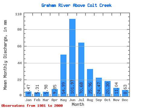
| Statistic | Jan | Feb | Mar | Apr | May | Jun | Jul | Aug | Sep | Oct | Nov | Dec | Annual |
|---|---|---|---|---|---|---|---|---|---|---|---|---|---|
| Mean | 6.47 | 5.35 | 5.98 | 9.85 | 54.98 | 101.97 | 70.67 | 35.96 | 24.47 | 20.29 | 11.04 | 8.63 | 354.61 |
| Standard Deviation | 1.07 | 0.65 | 1.20 | 3.09 | 22.91 | 25.71 | 23.99 | 22.67 | 10.30 | 5.69 | 2.11 | 1.80 | 52.76 |
| Min | 5.00 | 4.33 | 4.52 | 4.76 | 14.36 | 53.25 | 32.26 | 13.51 | 11.78 | 11.06 | 7.33 | 5.81 | 274.45 |
| Max | 8.86 | 6.71 | 8.96 | 16.14 | 93.73 | 160.23 | 120.63 | 101.89 | 43.48 | 30.43 | 14.85 | 12.54 | 470.89 |
| Coefficient of Variation | 0.17 | 0.12 | 0.20 | 0.31 | 0.42 | 0.25 | 0.34 | 0.63 | 0.42 | 0.28 | 0.19 | 0.21 | 0.15 |
 Return to R-Arctic Net Home Page