|
|
|||||||||||||||||
| Point ID: 8744 | Downloads | Plots | Site Data | Code: 12629 |
|
|
|||||||||||||||||
| Download | |
|---|---|
| Site Descriptor Information | Site Time Series Data |
| Link to all available data | |
| View: | Time Series | All |
| Units: | m3/s |
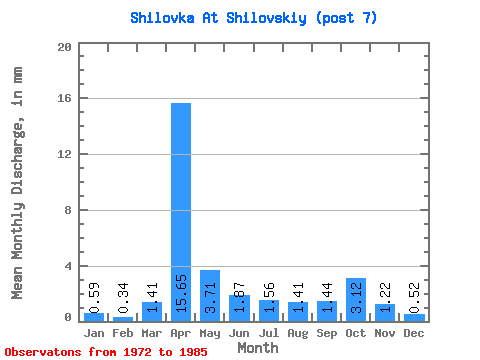
| Statistic | Jan | Feb | Mar | Apr | May | Jun | Jul | Aug | Sep | Oct | Nov | Dec | Annual |
|---|---|---|---|---|---|---|---|---|---|---|---|---|---|
| Mean | 0.56 | 0.36 | 1.41 | 15.64 | 3.67 | 1.86 | 1.55 | 1.42 | 1.45 | 3.13 | 1.23 | 0.51 | 31.59 |
| Standard Deviation | 0.82 | 0.52 | 3.41 | 16.11 | 4.67 | 2.27 | 2.04 | 2.18 | 2.05 | 7.32 | 2.28 | 0.78 | 26.52 |
| Min | 0.00 | 0.00 | 0.00 | 0.65 | 0.22 | 0.21 | 0.07 | 0.15 | 0.07 | 0.00 | 0.00 | 0.00 | 5.80 |
| Max | 2.27 | 1.35 | 12.61 | 44.52 | 17.06 | 9.33 | 7.20 | 7.42 | 6.82 | 28.19 | 8.62 | 2.15 | 76.51 |
| Coefficient of Variation | 1.48 | 1.42 | 2.42 | 1.03 | 1.27 | 1.22 | 1.32 | 1.54 | 1.42 | 2.33 | 1.85 | 1.52 | 0.84 |
 Return to R-Arctic Net Home Page