|
|
|||||||||||||||||
| Point ID: 8733 | Downloads | Plots | Site Data | Code: 12618 |
|
|
|||||||||||||||||
| Download | |
|---|---|
| Site Descriptor Information | Site Time Series Data |
| Link to all available data | |
| View: | Time Series | All |
| Units: | m3/s |
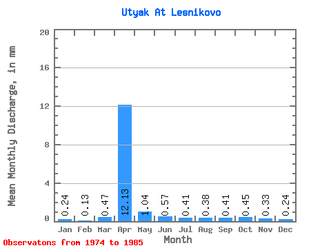
| Statistic | Jan | Feb | Mar | Apr | May | Jun | Jul | Aug | Sep | Oct | Nov | Dec | Annual |
|---|---|---|---|---|---|---|---|---|---|---|---|---|---|
| Mean | 0.24 | 0.13 | 0.47 | 12.13 | 1.04 | 0.57 | 0.40 | 0.38 | 0.41 | 0.45 | 0.34 | 0.24 | 16.95 |
| Standard Deviation | 0.49 | 0.24 | 0.69 | 9.47 | 0.66 | 0.52 | 0.39 | 0.33 | 0.33 | 0.38 | 0.33 | 0.42 | 11.81 |
| Min | 0.00 | 0.00 | 0.00 | 2.51 | 0.40 | 0.09 | 0.04 | 0.03 | 0.04 | 0.06 | 0.01 | 0.00 | 3.38 |
| Max | 1.40 | 0.56 | 1.75 | 31.14 | 2.38 | 1.63 | 1.05 | 0.84 | 1.15 | 0.98 | 0.81 | 1.26 | 38.87 |
| Coefficient of Variation | 2.01 | 1.79 | 1.46 | 0.78 | 0.63 | 0.92 | 0.97 | 0.87 | 0.81 | 0.85 | 0.98 | 1.76 | 0.70 |
 Return to R-Arctic Net Home Page