|
|
|||||||||||||||||
| Point ID: 8731 | Downloads | Plots | Site Data | Code: 12616 |
|
|
|||||||||||||||||
| Download | |
|---|---|
| Site Descriptor Information | Site Time Series Data |
| Link to all available data | |
| View: | Time Series | All |
| Units: | m3/s |
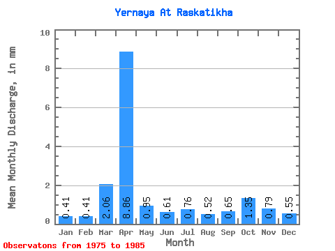
| Statistic | Jan | Feb | Mar | Apr | May | Jun | Jul | Aug | Sep | Oct | Nov | Dec | Annual |
|---|---|---|---|---|---|---|---|---|---|---|---|---|---|
| Mean | 0.41 | 0.41 | 2.06 | 8.87 | 0.96 | 0.61 | 0.76 | 0.52 | 0.65 | 1.35 | 0.78 | 0.55 | 18.09 |
| Standard Deviation | 0.27 | 0.36 | 1.24 | 7.04 | 0.79 | 0.16 | 0.37 | 0.17 | 0.51 | 1.03 | 0.50 | 0.65 | 9.45 |
| Min | 0.00 | 0.00 | 0.38 | 3.12 | 0.22 | 0.35 | 0.36 | 0.31 | 0.06 | 0.24 | 0.21 | 0.00 | 9.67 |
| Max | 0.80 | 1.15 | 4.12 | 24.05 | 2.83 | 0.86 | 1.42 | 0.77 | 1.75 | 2.83 | 1.87 | 2.06 | 36.05 |
| Coefficient of Variation | 0.65 | 0.88 | 0.60 | 0.79 | 0.83 | 0.26 | 0.49 | 0.33 | 0.78 | 0.76 | 0.64 | 1.18 | 0.52 |
 Return to R-Arctic Net Home Page