|
|
|||||||||||||||||
| Point ID: 8730 | Downloads | Plots | Site Data | Code: 12609 |
|
|
|||||||||||||||||
| Download | |
|---|---|
| Site Descriptor Information | Site Time Series Data |
| Link to all available data | |
| View: | Time Series | All |
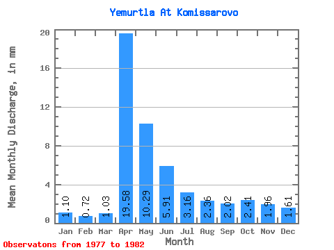
| Units: | m3/s |
| Statistic | Jan | Feb | Mar | Apr | May | Jun | Jul | Aug | Sep | Oct | Nov | Dec | Annual |
|---|---|---|---|---|---|---|---|---|---|---|---|---|---|
| Mean | 1.10 | 0.73 | 1.03 | 19.58 | 10.29 | 5.91 | 3.16 | 2.36 | 2.02 | 2.40 | 1.95 | 1.61 | 53.10 |
| Standard Deviation | 0.27 | 0.26 | 0.49 | 14.71 | 6.56 | 3.55 | 1.64 | 0.79 | 0.36 | 0.59 | 0.80 | 1.09 | 19.81 |
| Min | 0.80 | 0.51 | 0.45 | 12.22 | 3.50 | 1.57 | 1.28 | 1.79 | 1.65 | 1.79 | 1.32 | 0.44 | 35.01 |
| Max | 1.54 | 1.01 | 1.79 | 45.81 | 17.14 | 10.98 | 5.63 | 3.93 | 2.48 | 3.16 | 3.47 | 3.50 | 85.06 |
| Coefficient of Variation | 0.24 | 0.36 | 0.48 | 0.75 | 0.64 | 0.60 | 0.52 | 0.34 | 0.18 | 0.25 | 0.41 | 0.68 | 0.37 |
 Return to R-Arctic Net Home Page