|
|
|||||||||||||||||
| Point ID: 8723 | Downloads | Plots | Site Data | Code: 12505 |
|
|
|||||||||||||||||
| Download | |
|---|---|
| Site Descriptor Information | Site Time Series Data |
| Link to all available data | |
| View: | Time Series | All |
| Units: | m3/s |
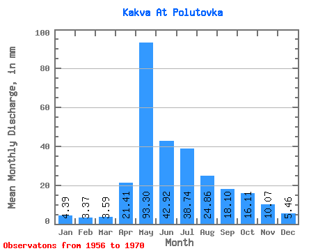
| Statistic | Jan | Feb | Mar | Apr | May | Jun | Jul | Aug | Sep | Oct | Nov | Dec | Annual |
|---|---|---|---|---|---|---|---|---|---|---|---|---|---|
| Mean | 4.39 | 3.40 | 3.58 | 21.41 | 93.28 | 42.92 | 38.74 | 24.86 | 18.10 | 16.11 | 10.07 | 5.46 | 280.63 |
| Standard Deviation | 0.97 | 0.83 | 0.90 | 15.51 | 43.26 | 20.14 | 34.32 | 23.30 | 13.89 | 8.61 | 3.21 | 1.80 | 79.78 |
| Min | 2.86 | 2.44 | 2.11 | 5.34 | 53.56 | 22.81 | 9.78 | 5.37 | 3.75 | 9.59 | 4.98 | 3.64 | 189.66 |
| Max | 6.53 | 4.90 | 5.39 | 51.84 | 203.53 | 95.04 | 127.83 | 72.13 | 44.06 | 39.10 | 15.24 | 9.55 | 430.71 |
| Coefficient of Variation | 0.22 | 0.25 | 0.25 | 0.72 | 0.46 | 0.47 | 0.89 | 0.94 | 0.77 | 0.54 | 0.32 | 0.33 | 0.28 |
 Return to R-Arctic Net Home Page