|
|
|||||||||||||||||
| Point ID: 8717 | Downloads | Plots | Site Data | Code: 12466 |
|
|
|||||||||||||||||
| Download | |
|---|---|
| Site Descriptor Information | Site Time Series Data |
| Link to all available data | |
| View: | Time Series | All |
| Units: | m3/s |
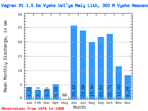
| Statistic | Jan | Feb | Mar | Apr | May | Jun | Jul | Aug | Sep | Oct | Nov | Dec | Annual |
|---|---|---|---|---|---|---|---|---|---|---|---|---|---|
| Mean | 4.20 | 3.20 | 3.50 | 5.18 | 25.65 | 23.88 | 19.94 | 21.62 | 22.70 | 11.43 | 8.29 | ||
| Standard Deviation | 2.72 | 2.00 | 1.78 | 6.89 | 14.26 | 10.30 | 11.69 | 19.60 | 9.45 | 3.33 | |||
| Min | 0.55 | 0.32 | 0.97 | 5.18 | 19.05 | 8.39 | 10.32 | 8.12 | 6.58 | 4.75 | 3.90 | ||
| Max | 7.00 | 4.56 | 4.84 | 5.18 | 32.79 | 36.46 | 34.20 | 28.42 | 44.53 | 18.11 | 11.97 | ||
| Coefficient of Variation | 0.65 | 0.62 | 0.51 | 0.27 | 0.60 | 0.52 | 0.54 | 0.86 | 0.83 | 0.40 |
 Return to R-Arctic Net Home Page