|
|
|||||||||||||||||
| Point ID: 870 | Downloads | Plots | Site Data | Code: 07EE007 |
|
|
|||||||||||||||||
| Download | |
|---|---|
| Site Descriptor Information | Site Time Series Data |
| Link to all available data | |
| View: | Time Series | All |
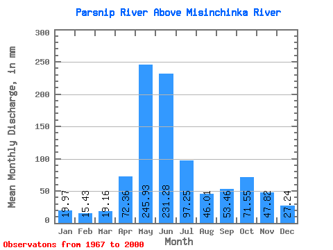
| Units: | m3/s |
| Statistic | Jan | Feb | Mar | Apr | May | Jun | Jul | Aug | Sep | Oct | Nov | Dec | Annual |
|---|---|---|---|---|---|---|---|---|---|---|---|---|---|
| Mean | 19.97 | 15.56 | 19.16 | 72.36 | 245.89 | 231.28 | 97.23 | 46.01 | 53.46 | 71.54 | 47.82 | 27.23 | 944.91 |
| Standard Deviation | 9.89 | 8.22 | 11.25 | 33.44 | 52.18 | 79.69 | 41.00 | 21.27 | 31.59 | 29.32 | 17.94 | 14.14 | 152.32 |
| Min | 11.15 | 5.83 | 7.11 | 11.27 | 150.30 | 73.53 | 31.21 | 17.93 | 15.29 | 28.42 | 19.62 | 14.48 | 655.67 |
| Max | 48.48 | 45.51 | 61.76 | 159.75 | 343.22 | 391.97 | 204.40 | 109.85 | 139.65 | 150.30 | 84.64 | 89.08 | 1287.41 |
| Coefficient of Variation | 0.49 | 0.53 | 0.59 | 0.46 | 0.21 | 0.34 | 0.42 | 0.46 | 0.59 | 0.41 | 0.38 | 0.52 | 0.16 |
 Return to R-Arctic Net Home Page