|
|
|||||||||||||||||
| Point ID: 8692 | Downloads | Plots | Site Data | Code: 11609 |
|
|
|||||||||||||||||
| Download | |
|---|---|
| Site Descriptor Information | Site Time Series Data |
| Link to all available data | |
| View: | Time Series | All |
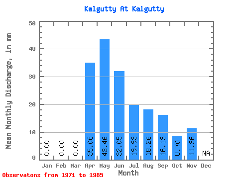
| Units: | m3/s |
| Statistic | Jan | Feb | Mar | Apr | May | Jun | Jul | Aug | Sep | Oct | Nov | Dec | Annual |
|---|---|---|---|---|---|---|---|---|---|---|---|---|---|
| Mean | 0.00 | 0.00 | 0.00 | 35.06 | 43.46 | 32.05 | 19.93 | 18.26 | 16.13 | 8.70 | 11.36 | ||
| Standard Deviation | 0.00 | 0.00 | 0.00 | 28.06 | 25.05 | 31.63 | 18.12 | 16.36 | 13.96 | 3.57 | 4.67 | ||
| Min | 0.00 | 0.00 | 0.00 | 7.41 | 6.22 | 2.66 | 2.27 | 2.15 | 3.01 | 4.30 | 5.44 | ||
| Max | 0.00 | 0.00 | 0.00 | 84.82 | 97.56 | 118.03 | 55.71 | 49.73 | 43.39 | 14.11 | 18.28 | ||
| Coefficient of Variation | 0.80 | 0.58 | 0.99 | 0.91 | 0.90 | 0.87 | 0.41 | 0.41 |
 Return to R-Arctic Net Home Page