|
|
|||||||||||||||||
| Point ID: 8677 | Downloads | Plots | Site Data | Code: 11593 |
|
|
|||||||||||||||||
| Download | |
|---|---|
| Site Descriptor Information | Site Time Series Data |
| Link to all available data | |
| View: | Time Series | All |
| Units: | m3/s |
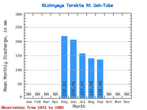
| Statistic | Jan | Feb | Mar | Apr | May | Jun | Jul | Aug | Sep | Oct | Nov | Dec | Annual |
|---|---|---|---|---|---|---|---|---|---|---|---|---|---|
| Mean | 218.77 | 205.47 | 157.95 | 140.46 | 136.48 | ||||||||
| Standard Deviation | 284.71 | 278.73 | 210.93 | 163.36 | 129.67 | ||||||||
| Min | 32.79 | 22.22 | 13.12 | 9.84 | 36.50 | ||||||||
| Max | 967.36 | 946.87 | 688.63 | 497.89 | 404.67 | ||||||||
| Coefficient of Variation | 1.30 | 1.36 | 1.33 | 1.16 | 0.95 |
 Return to R-Arctic Net Home Page