|
|
|||||||||||||||||
| Point ID: 8674 | Downloads | Plots | Site Data | Code: 11565 |
|
|
|||||||||||||||||
| Download | |
|---|---|
| Site Descriptor Information | Site Time Series Data |
| Link to all available data | |
| View: | Time Series | All |
| Units: | m3/s |
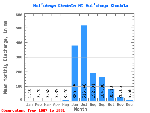
| Statistic | Jan | Feb | Mar | Apr | May | Jun | Jul | Aug | Sep | Oct | Nov | Dec | Annual |
|---|---|---|---|---|---|---|---|---|---|---|---|---|---|
| Mean | 1.10 | 0.71 | 0.63 | 0.39 | 8.20 | 380.46 | 516.39 | 192.88 | 164.36 | 82.17 | 26.65 | 6.66 | 1140.81 |
| Standard Deviation | 2.91 | 1.73 | 1.22 | 0.60 | 13.09 | 209.97 | 168.30 | 110.90 | 51.70 | 39.09 | 9.68 | 6.69 | 285.60 |
| Min | 0.00 | 0.00 | 0.00 | 0.00 | 0.00 | 0.02 | 259.69 | 104.48 | 85.22 | 32.66 | 10.60 | 0.00 | 865.61 |
| Max | 7.71 | 4.25 | 3.04 | 1.37 | 31.04 | 756.00 | 793.26 | 501.11 | 247.42 | 158.65 | 41.05 | 18.47 | 1435.78 |
| Coefficient of Variation | 2.64 | 2.44 | 1.93 | 1.53 | 1.60 | 0.55 | 0.33 | 0.57 | 0.32 | 0.48 | 0.36 | 1.00 | 0.25 |
 Return to R-Arctic Net Home Page