|
|
|||||||||||||||||
| Point ID: 8669 | Downloads | Plots | Site Data | Code: 11527 |
|
|
|||||||||||||||||
| Download | |
|---|---|
| Site Descriptor Information | Site Time Series Data |
| Link to all available data | |
| View: | Time Series | All |
| Units: | m3/s |
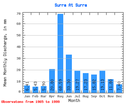
| Statistic | Jan | Feb | Mar | Apr | May | Jun | Jul | Aug | Sep | Oct | Nov | Dec | Annual |
|---|---|---|---|---|---|---|---|---|---|---|---|---|---|
| Mean | 6.41 | 5.48 | 5.90 | 20.80 | 68.58 | 33.30 | 19.26 | 17.23 | 15.82 | 19.13 | 11.80 | 7.39 | 227.62 |
| Standard Deviation | 1.01 | 1.05 | 1.28 | 17.66 | 31.66 | 16.94 | 13.21 | 14.42 | 8.82 | 14.36 | 7.54 | 2.23 | 64.00 |
| Min | 4.52 | 2.86 | 2.20 | 5.96 | 15.21 | 6.28 | 5.13 | 5.49 | 6.65 | 6.42 | 5.46 | 4.32 | 94.89 |
| Max | 8.08 | 7.54 | 9.78 | 67.42 | 133.41 | 73.78 | 53.07 | 69.66 | 34.98 | 61.77 | 35.94 | 14.41 | 357.39 |
| Coefficient of Variation | 0.16 | 0.19 | 0.22 | 0.85 | 0.46 | 0.51 | 0.69 | 0.84 | 0.56 | 0.75 | 0.64 | 0.30 | 0.28 |
 Return to R-Arctic Net Home Page