|
|
|||||||||||||||||
| Point ID: 8649 | Downloads | Plots | Site Data | Code: 11419 |
|
|
|||||||||||||||||
| Download | |
|---|---|
| Site Descriptor Information | Site Time Series Data |
| Link to all available data | |
| View: | Time Series | All |
| Units: | m3/s |
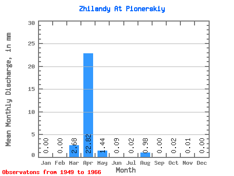
| Statistic | Jan | Feb | Mar | Apr | May | Jun | Jul | Aug | Sep | Oct | Nov | Dec | Annual |
|---|---|---|---|---|---|---|---|---|---|---|---|---|---|
| Mean | 0.00 | 0.00 | 2.68 | 22.82 | 1.44 | 0.09 | 0.02 | 0.98 | 0.01 | 0.01 | 0.01 | 0.00 | 28.55 |
| Standard Deviation | 0.00 | 0.00 | 6.68 | 13.62 | 1.45 | 0.17 | 0.04 | 4.01 | 0.01 | 0.01 | 0.02 | 0.00 | 16.76 |
| Min | 0.00 | 0.00 | 0.00 | 1.78 | 0.03 | 0.00 | 0.00 | 0.00 | 0.00 | 0.00 | 0.00 | 0.00 | 2.48 |
| Max | 0.00 | 0.00 | 25.71 | 50.21 | 4.29 | 0.71 | 0.14 | 16.54 | 0.04 | 0.05 | 0.06 | 0.00 | 69.75 |
| Coefficient of Variation | 2.49 | 0.60 | 1.01 | 1.88 | 1.82 | 4.09 | 1.93 | 1.16 | 1.30 | 0.59 |
 Return to R-Arctic Net Home Page