|
|
|||||||||||||||||
| Point ID: 8639 | Downloads | Plots | Site Data | Code: 11354 |
|
|
|||||||||||||||||
| Download | |
|---|---|
| Site Descriptor Information | Site Time Series Data |
| Link to all available data | |
| View: | Time Series | All |
| Units: | m3/s |
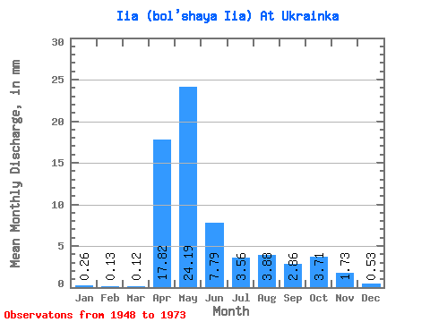
| Statistic | Jan | Feb | Mar | Apr | May | Jun | Jul | Aug | Sep | Oct | Nov | Dec | Annual |
|---|---|---|---|---|---|---|---|---|---|---|---|---|---|
| Mean | 0.26 | 0.13 | 0.12 | 17.81 | 24.18 | 7.79 | 3.56 | 3.88 | 2.86 | 3.71 | 1.73 | 0.53 | 67.02 |
| Standard Deviation | 0.38 | 0.14 | 0.09 | 15.54 | 16.91 | 6.57 | 3.91 | 6.13 | 4.33 | 4.19 | 2.21 | 0.86 | 41.22 |
| Min | 0.02 | 0.00 | 0.02 | 0.88 | 1.28 | 0.58 | 0.08 | 0.04 | 0.05 | 0.05 | 0.04 | 0.02 | 3.82 |
| Max | 1.85 | 0.68 | 0.46 | 48.58 | 69.02 | 23.30 | 11.66 | 18.94 | 18.11 | 13.92 | 8.39 | 4.05 | 146.18 |
| Coefficient of Variation | 1.47 | 1.13 | 0.74 | 0.87 | 0.70 | 0.84 | 1.10 | 1.58 | 1.51 | 1.13 | 1.28 | 1.62 | 0.61 |
 Return to R-Arctic Net Home Page